Distance: 17,5 km
Duration (average) : 05h
Level: Medium
Elevation: 567 D +
Departure: LAROQUE-DE-FA
White and red GR
GR 36: This European trail (Switzerland-Spain) crosses the Aude from North to South. From the beech groves of the Montagne Noire: Pic de Nore, along the Canal du Midi, to the City of Carcassonne, then by the backbone of the Alaric, we reach Lagrasse and it is the crossing of the wild Corbières. The path passes at the foot of Villerouge Termenès, Termes, Peyrepertuse. The GR 36: information from the Departmental Hiking Committee 04 68 47 69 26

Walking

Your itinerary

Map List

LAROQUE-DE-FA

IGN map reference (s): IGN 2446 West Capendu, IGN 2447 West Tuchan

1

Step 1

(Laroque de Fa: old castrum; Gallo-Roman temple on the rock: Castelnau; the Roc de Peyrat (second rock) was fortified by a wall connecting the two rocks. From the church, follow the rue du Pont-de -Ture along the cliff and go up towards the ruins of the medieval castle. On the D 613, an aqueduct bridge supplied a turnery.) On the D 613, turn left (bridge), then take a small road on the left leading to the right at the junction of Borde Grande. (Junction with the GR 36 arriving from Rouffiac-des-Corbières)
2

Step 2

Follow the D 8010 to the right, pass in front of the stable then in front of the buildings of the Borde Grande farm (531 m).
3

Step 3

Go up the main track in the woods, leaving the paths to the left. Come out onto a track at the entrance of a bend to the right (610 m). Walk about 150 m.
4

Step 4

Fork to the left. Go up the track, cross the woods, pass in front of a transformer, the path becomes tarred. Turn right onto the D 613. Avoid entering the village on the left.
5

Step 5

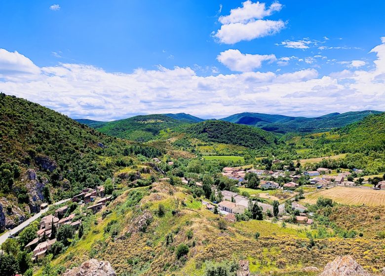
(The village is located in the center of a semi-desert plateau, swept by the winds.) At the last houses, turn left in front of the Sainte Anne chapel (place of pilgrimage; inside, a superb polychrome statue of Saint Anne ). Follow the motorable lane for about 1,5 km. We walk along the Caulière stream. Just before the bridge, take a left uphill path. Cross the Bois du Teil due north; at the pass (508 m) go back down, ignoring the paths on the left, plunging into the woods of the valley of Caulière. Ford the stream. Reach a large bend to the right, with two route possibilities.
6

Step 6

Leave the PR which joins Termes on the left and continue to the right on the GR 36 uphill in the national forest of Termenès, on the slope of the Caulière stream. A few hairpin bends further on, you reach a plateau (panorama of Mont Tauch (wind turbines) and the Mouthoumet plateau). Cross it to the east for about 300 m.
7

Step 7

A steep descent allows access to the cliff of the Nitable Roc. Walk along it and cross an area of ​​chaotic scree. Descents and flats follow one another.
8

Step 8

Go down a steep and delicate passage in the rocks, Caune Pount (475 m) (!) Danger of falling); (view: the rock of Caune Pount, a sort of natural bridge, spans a narrow defile at the bottom of which is a cave of Neolithic settlement). Continue the steep descent obliquely to the left.
9

Step 9

Cross the Nougairole stream. Follow the course of the Sou (dam) to walk along the "béal" (regionalism: small irrigation canal) overlooking the river. Follow the Sou valley, dotted with small gardens. Turn left and continue towards the town hall (WC - water), cross the Sou on a metal footbridge, turn right onto the D 40.
Full screen Close

Accommodation

  • Accommodation
  • Send

where to have a drink, to eat

  • where to have a drink, to eat
  • Send

Shops and Services

  • Shops and Services
  • Send

To visit

  • To visit
  • Send
Download :

Be careful, the fire risk is often high, especially in summer, and can lead to flower bed closures. Find out before you go consulting the fire risk map for outdoor activities.
Fires strictly prohibited. Do not smoke and never throw cigarette butts in nature. Fires are numerous and catastrophic in our region. In the event of a fire or accident: give alert 18 or 112 from a cell phone.
Protect yourself from the sun and take enough water with you.
Avoid picking flowers and plants. Take all your trash. Close fences and keep dogs on a leash in pasture areas, villages and protected areas.

Mountain bike routes: the routes are often shared with hikers or other users (cars, tractors, etc.). Be careful and always anticipate that a pedestrian may be present around a bend to have time to brake if necessary. Pedestrians have priority in principle, slow down at crossings or stop if the configuration of the terrain requires you to do so.
Thank you and happy hiking!

Reviews

Add a review

Your email address will not be published. Required fields are marked with *